Mahameru: Kisah Pendakian Menuju Atap Pulau Jawa
Gunung Semeru adalah gunung berapi berbentuk kerucut yang terletak di Provinsi Jawa Timur, Indonesia. Gunung ini merupakan gunung tertinggi di Pulau Jawa, dengan puncak bernama Mahameru yang memiliki ketinggian 3.676 meter di atas permukaan laut (mdpl). Gunung Semeru termasuk dalam kawasan Taman Nasional Bromo Tengger Semeru, yang secara administratif berada di dua wilayah, yaitu Kabupaten Malang dan Kabupaten Lumajang.

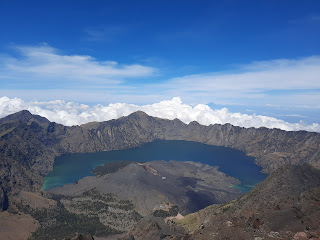
Puncak Mahameru
Perjalanan ini bermula ketika seorang kawan mengajak saya pada pertengahan 2017, tepatnya saat kami masih kelas dua pada sekolah tingkat atas. Seperti biasa, di setiap libur pergantian semester, kegiatan mendaki gunung selalu jadi prioritas untuk mengisi waktu liburan sekolah. Ya, Gunung Semeru memang salah satu tempat yang ingin saya kunjungi sejak pertama kali mengenal dunia pendakian. Semeru, nama yang tentu sudah akrab di telinga para pendaki, membuat siapa pun ingin segera datang dan bertamu dengan keganasan hutannya.
Perjalanan Menuju Ranu Pani
Kami berempat berangkat (saya, Argo, Sasdra, dan ayah Argo) menggunakan kereta api dari Stasiun Pasar Senen menuju Stasiun Malang. Sesampainya di Malang, paman Argo langsung mengantar kami ke Pasar Tumpang. Pasar Tumpang merupakan titik kumpul bagi para pendaki yang ingin menuju Gunung Semeru menggunakan mobil jeep. Kami bersama beberapa pendaki lain langsung menyewa sebuah mobil jeep untuk mengantar kami ke pos registrasi di Desa Ranu Pani dengan biaya Rp50.000 per orang. Ranu Pani adalah desa terakhir sebelum memasuki jalur pendakian Gunung Semeru—tempat berkumpulnya para pendaki karena jalur resmi pendakian saat itu hanya melewati desa ini.
Dalam perjalanan menuju Desa Ranu Pani, kami disuguhi berbagai pemandangan indah, mulai dari perbukitan Bromo hingga lautan pasir. Setelah kurang lebih 3 jam menggunakan mobil jeep, kami tiba di Desa Ranu Pani untuk melakukan registrasi pendakian. Setelah mendapatkan izin masuk kawasan konservasi dengan biaya Rp20.000, kami mengikuti briefing yang diberikan oleh petugas Taman Nasional sebelum mendaki Gunung Semeru. Setelah seluruh perlengkapan dikemas ulang, kami langsung memulai pendakian begitu matahari mulai terbenam.

Menumpangi mobil jeep untuk diantar menuju Desa Ranu Pani
Menuju Ranu Kumbolo
Perjalanan dimulai melalui jalur yang landai dan ramah, menyusuri ladang kentang milik masyarakat setempat. Setelah melewati gerbang selamat datang, jalur mulai memasuki beberapa perbukitan. Karena kami berjalan di malam hari, tubuh tidak terlalu terasa lelah atau kepanasan. Setelah lebih dari satu jam berjalan dengan jarak tempuh 2 km dengan beberapa kali istirahat, kami tiba di Watu Rejeng untuk menarik napas sejenak. Saya mencoba pisang goreng di sebuah warung—harganya murah, hanya Rp2.000 per buah. Sepertinya Gunung Semeru memang salah satu gunung yang ramah di kantong para pendaki.
Kami melanjutkan pendakian menuju Ranu Kumbolo, tempat kami akan bermalam nantinya. Semakin jauh berjalan, udara dingin semakin terasa menusuk. Dari kejauhan, samar-samar terlihat sebuah danau besar di ujung jalan, tersaput gelapnya malam dan hanya dibantu oleh pantulan cahaya bulan. "Ah, ini surganya para pendaki," gumam dalam hati. Pukul 9 malam, kami tiba di tepi Danau Ranu Kumbolo dan langsung mendirikan tenda. Ranu Kumbolo sangat ramai malam itu—memang sedang musim liburan bulan Juni. Kami menikmati seduhan minuman hangat sebagai penutup setelah makan malam. Udara dingin di Ranu Kumbolo membuat kami ingin segera tidur, berlindung dalam pelukan sleeping bag.
Pagi di Ranu Kumbolo
Sungguh, Ranu Kumbolo sangat indah di pagi itu. Matahari yang muncul di antara perbukitan di ujung danau benar-benar menambah eksotisme tempat ini. Embun tipis menemani saat menikmati pagi saat saya berjalan di tepi danau, sesekali menyentuh airnya yang dingin dan tenang.
Tiba-tiba saya tidak bisa lagi menahan buang air kecil. Saya bergegas masuk ke kamar mandi di tepi danau—setelah sebelumnya mengambil air dari Danau Ranu Kumbolo untuk keperluan minum. Sayangnya, sampah berserakan di mana-mana: botol plastik, tisu basah, dan kotoran manusia memenuhi kamar mandi tersebut, mengganggu keindahan kawasan Ranu Kumbolo. Sangat disayangkan, fasilitas yang sengaja dibangun petugas untuk mempermudah para pendaki ini ternyata tidak dirawat dengan baik. Tak lama setelah sarapan, kami segera mengemas perlengkapan untuk melanjutkan perjalanan menuju Kalimati, tempat kami akan bermalam berikutnya.

Danau Ranu Kumbolo saat pagi hari
Tanjakan Cinta dan Oro-oro Ombo
Setelah meninggalkan Ranu Kumbolo, kami harus melewati tempat yang cukup terkenal: Tanjakan Cinta. Ada mitos yang berkembang di sini—jika seseorang melewati tanjakan ini sambil memikirkan orang yang dicintainya tanpa menoleh ke belakang, kelak ia akan berjodoh dengan orang tersebut. Namun, jika ia menoleh ke belakang saat melewati tanjakan ini, maka ia akan gagal bersama orang yang dicintainya. Percaya atau tidak, hampir semua pendaki mengenal cerita ini. Bisa dimengerti, kisah ini memang menjadi daya tarik tersendiri dalam perjalanan mendaki Gunung Semeru.
Di tengah perjalanan melewati Tanjakan Cinta, saya terpikirkan mitos ini. Ketika saya menoleh ke belakang benar saja, pemandangan dari atas sini sangat indah. Saya merasa tidak menyesal menoleh ke belakang. Sungguh, Ranu Kumbolo terlihat sangat cantik dari kejauhan.

Tanjakan Cinta dengan pemandangan Danau Ranu Kumbulu
Setelah melewati Tanjakan Cinta, kami berdiri di atas sebuah bukit. Di hadapan kami terbentang padang rumput yang sangat luas bernama Oro-oro Ombo. Tempat ini dikelilingi perbukitan dan gunung dengan pemandangan yang sangat indah—padang rumput luas dengan lereng yang dipenuhi pohon cemara, seperti berada di negeri khayangan.

Pemandangan di Oro-oro Ombo
Menuju Kalimati
Perjalanan berlanjut memasuki hutan cemara yang disebut Cemoro Kandang. Di sini banyak warung yang menjual makanan, seperti pisang goreng, kopi, semangka, dan lainnya. Saya membeli dua buah semangka, segar sekali. Jalur mulai menanjak seiring kami memasuki hutan yang lebih lebat. Rasa lelah dan capek terasa di seluruh tubuh. Setelah berjalan beberapa jam, kami akhirnya tiba di suatu pos bernama Jambangan. Dari tempat ini, Puncak Mahameru yang megah sudah dapat terlihat dari kejauhan—pemandangan ini sungguh menambah semangat kami untuk melanjutkan pendakian.

Puncak Mahameru yang terlihat dari Pos Jambangan
Tidak butuh waktu lama, sore harinya kami tiba di Kalimati. Pos Kalimati berada di ketinggian 2.700 mdpl, tempat para pendaki biasa mendirikan tenda untuk beristirahat sekaligus bersiap menuju puncak Gunung Semeru keesokan harinya. Tempat ini berupa hamparan padang rumput luas di tepi hutan cemara, dan di beberapa titik dipenuhi bunga edelweiss. Di Kalimati juga terdapat sumber air bernama Sumber Mani, terletak di sisi barat sepanjang tepi hutan Kalimati.

Sampai di Pos Kalimati
Malam itu, kami mengobrol bersama pendaki lain di luar tenda. Kalimati sangat ramai malam itu, dipenuhi banyak pendaki—mungkin mereka juga akan menuju puncak besok. Entahlah, yang jelas saat itu saya harus segera tidur karena pada pukul 1 dini hari kami harus melanjutkan perjalanan menuju puncak Gunung Semeru, yang dikenal sebagai medan paling berat dalam pendakian gunung ini. Yang pasti, saya tidak sabar lagi untuk berdiri di titik tertinggi Pulau Jawa—Mahameru, kami datang!
Summit Attack: Menuju Mahameru
Suara ribut di luar tenda memaksa kami membuka mata dan melawan rasa kantuk yang masih nyaman membungkus tubuh. Cahaya senter kepala (headlamp) dari para pendaki yang bersama-sama menuju puncak menerangi sepanjang jalur pendakian. Dari Kalimati, kami harus menuju Arcopodo melalui jalur yang cukup sempit, berbelok ke kiri (timur) dan berjalan sekitar 500 meter dari Kalimati.
Arcopodo berjarak sekitar 60 menit dari Kalimati, melewati hutan cemara yang sangat terjal dengan tanah yang rawan longsor dan berdebu. Sebenarnya bisa juga mendirikan tenda di Arcopodo, namun karena tanahnya kurang stabil dan sering longsor, demi keamanan hal ini tidak disarankan. Arcopodo berada di ketinggian 2.900 mdpl dan menjadi batas vegetasi terakhir di Gunung Semeru. Setelah ini, jalur sepenuhnya berupa pasir.
"Awas! Batu... batu! Hindari!", teriakan ini sering terdengar dari para pendaki selama perjalan menuju puncak Mahameru, untuk memberi tahu pendaki lain di bawah bahwa ada batu yang menggelinding turun. Memang, jalur menuju puncak sangat berbahaya. Banyak batu besar yang bisa dengan mudah meluncur turun jika pendaki salah melangkah. Beberapa kali saya harus menghindar karena batu besar meluncur dari atas. Sangat ramai, kami bahkan harus berbaris untuk melewati jalur yang sempit ini. Naik tiga langkah, turun dua langkah, begitulah rasanya berjalan di jalur berpasir menuju puncak. Keikhlasan dan kesabaran sangat dibutuhkan saat berkomitmen untuk mencapai puncak.
Mahameru, Puncak Para Dewa
Garis kuning di ufuk timur perlahan muncul menemani perjalanan kami. Tepat saat fajar baru bangun dari tidurnya, kami tiba di titik tertinggi Pulau Jawa, Mahameru. Sungguh, tidak menyangka anak dengan pengalaman minim seperti saya bisa mencapai tempat yang sering dijuluki para pendaki sebagai "Puncak Abadi Para Dewa". Saya bersyukur kepada Tuhan karena bisa menyaksikan ciptaan alam yang begitu indah dan megah ini.

Jalur berpasir menuju puncak Gunung Semeru yang dilalui para pendaki
Asap dari kawah Jonggring Saloka menyembur setiap 10–15 menit. Memang, Gunung Semeru masih aktif, sehingga para pendaki disarankan turun paling lambat pukul 9 pagi, karena abu vulkanik bisa terbawa angin hingga ke puncak dan membahayakan keselamatan pendaki. Kami bergiliran mengabadikan momen dengan kamera ponsel yang kami bawa. Tidak lama kami berada di puncak, kami memutuskan segera turun dan kembali ke Ranu Kumbolo. Keesekon harinya kami kembali ke Desa Ranu Pani, tempat awal memulai pendakian ini.

Plakat di puncak Mahameru dengan ketinggian 3.676 mdpl
Semeru yang Tak Pernah Selesai Bercerita
Banyak kenangan dalam dunia pendakian yang berkaitan dengan Gunung Semeru. Mulai dari lagu "Mahameru" karya Dewa 19 yang menceritakan kisah perjalanan dan keindahan gunung ini, hingga film viral berjudul "5 cm" tahun 2012 tentang perjalanan lima sahabat menuju puncak Gunung Semeru, yang berhasil menarik minat banyak orang untuk mencoba aktivitas mendaki.
Siapa yang tidak mengenal sosok Soe Hok Gie? Tokoh aktivis dan inspirasi dunia pecinta alam yang erat kaitannya dengan Gunung Semeru. Ia wafat dalam pelukan maut Gunung Semeru pada 16 Desember 1969. Ah, Gunung Semeru memang tidak pernah berhenti menyimpan cerita. Semoga saya dapat mengunjunginya kembali dalam pendakian-pendakian selanjutnya.

Komentar
Posting Komentar